Investigating seasonal and interannual oceanographic variability through satellite remote sensing to identify potential marine productivity hotspots and support sustainable fisheries management in the Northern Bay of Bengal.
The Northern Bay of Bengal is an ecologically important marine region that supports diverse fish populations, commercially valuable fisheries, and the livelihoods of millions of people across the coastal countries of South Asia. Its productivity is strongly influenced by seasonal changes in oceanographic conditions, particularly sea surface temperature (SST), chlorophyll-a (Chl-a) concentration, freshwater discharge, and ocean circulation.
Sea surface temperature regulates several biological and physical processes in marine ecosystems, including phytoplankton growth, nutrient cycling, stratification, and the distribution of aquatic organisms. Chlorophyll-a, a photosynthetic pigment found in phytoplankton, is widely used as an indicator of phytoplankton biomass and a proxy for marine primary productivity.
In the Northern Bay of Bengal, these parameters exhibit considerable seasonal and interannual variations due to the influence of the southwest monsoon, northeast monsoon, river discharge from the Ganges–Brahmaputra–Meghna (GBM) river system, and regional ocean circulation.
Changes in SST and Chl-a can influence the environmental conditions supporting fish feeding, spawning, migration, and habitat suitability. Understanding their spatial and temporal relationships is therefore important for identifying potentially productive marine areas and improving fisheries planning.
Satellite remote sensing provides an effective approach for monitoring these changes over large marine areas. Integrating MODIS, VIIRS, and NOAA OISST datasets can help develop a comprehensive understanding of oceanographic variability and its implications for marine fisheries productivity in the Northern Bay of Bengal.
Why are SST and Chlorophyll-a important indicators of marine productivity?
Sea surface temperature and chlorophyll-a represent two important but different components of marine ecosystem dynamics.
Sea Surface Temperature (SST)
SST describes the temperature of the uppermost layer of the ocean and influences marine biological processes and physical oceanographic conditions.
Seasonal SST changes can influence:
- Phytoplankton growth and photosynthetic activity.
- Water-column stratification and vertical nutrient mixing.
- Distribution and migration of commercially important fish species.
- Spawning, feeding, and reproductive conditions.
- Marine heatwave occurrence and thermal habitat suitability.
In tropical marine ecosystems, elevated SST may strengthen surface-water stratification and reduce the upward transport of nutrients under certain conditions. However, the relationship between temperature and productivity is influenced by several interacting environmental factors.
Chlorophyll-a concentration
Chlorophyll-a is an important indicator of phytoplankton biomass and is commonly used to investigate variations in marine primary productivity.
Phytoplankton form the foundation of marine food webs and support zooplankton, small pelagic fish, and higher trophic-level organisms.
Changes in Chl-a concentration can provide information about:
- Phytoplankton biomass distribution.
- Seasonal phytoplankton blooms.
- Nutrient availability and riverine influence.
- Potentially productive marine environments.
- Spatial and temporal variations in marine ecosystem conditions.
However, higher Chl-a concentration does not automatically indicate higher fish abundance or fisheries yield. Fish production also depends on food-web transfer efficiency, habitat conditions, species biology, and fishing pressure.
What is happening in the Northern Bay of Bengal?
The Northern Bay of Bengal experiences distinct seasonal oceanographic conditions influenced by monsoon circulation, freshwater discharge, coastal processes, and regional atmospheric variability.
Previous satellite-based research has identified considerable seasonal and annual variations in SST and Chl-a across the region.
A study by Rouf et al. (2020), using MODIS-Aqua observations from 2002–2018, reported an average annual Chl-a concentration of 2.43 ± 0.24 mg m⁻³ in the Northern Bay of Bengal shelf region. Higher concentrations were observed during the northeast monsoon (October–February), while lower concentrations occurred during the pre-monsoon season (March–May). The study also identified a declining Chl-a trend over the investigated period. czasopisma.bg.ug.edu.pl+1
More recent research has demonstrated that productivity patterns are spatially heterogeneous. A 2025 MODIS-based study covering 2003–2022 identified a warming trend alongside increasing Chl-a in some northern coastal areas and slight declines in parts of the open ocean. These differences indicate that coastal and offshore waters may respond differently to changing oceanographic conditions. ScienceDirect
These findings highlight the importance of examining seasonal and interannual variability rather than relying only on annual average values.
Assessing seasonal and interannual SST and Chlorophyll-a patterns
An important component of this research is the examination of seasonal cycles and long-term changes in SST and Chl-a concentration across the Northern Bay of Bengal.
Satellite-derived observations can be analyzed to identify recurring seasonal patterns, unusual oceanographic conditions, and areas experiencing persistent changes in marine productivity.
The assessment can be organized into the following components:
1. Seasonal SST variability
Monthly and seasonal SST observations can be used to examine temperature changes during the pre-monsoon, southwest monsoon, post-monsoon, and northeast monsoon periods.
The analysis can identify seasonal warming and cooling patterns, coastal-to-offshore temperature gradients, and areas experiencing unusual thermal conditions.
2. Seasonal Chlorophyll-a variability
Monthly Chl-a composites can help identify periods of elevated phytoplankton biomass and potential bloom development.
Particular attention should be given to coastal waters influenced by river discharge, estuarine mixing, and nutrient enrichment.
3. Interannual variability and long-term trends
Time-series analysis can identify year-to-year fluctuations and long-term changes in SST and Chl-a.
Methods such as linear regression, the Mann–Kendall trend test, and Sen’s slope estimator can help determine the direction and magnitude of temporal changes.
4. SST–Chl-a relationships
Correlation and regression analysis can investigate how temperature variability is associated with phytoplankton biomass.
A negative relationship may indicate the influence of nutrient-rich upwelling or vertical mixing in certain locations, whereas riverine nutrient inputs and other environmental processes may produce different patterns.
5. Identification of marine productivity hotspots
Combining Chl-a concentration, SST gradients, thermal fronts, and seasonal persistence can help identify potentially productive marine areas.
A 2022 study of thermal fronts in the Northern Bay of Bengal found that areas of elevated thermal-front density and Chl-a frequently occurred between the 10 and 50 m isobaths, with spatial correspondence to clusters of fishing vessels detected through VIIRS nighttime observations. ScienceDirect
Integrating MODIS, VIIRS, and NOAA OISST satellite datasets
Satellite remote sensing provides an opportunity to monitor marine environmental conditions across large spatial and temporal scales.
Integrating multiple satellite products can improve the assessment of marine productivity patterns and their potential relationships with fisheries activities.
The proposed research can incorporate three major satellite data sources:
1. MODIS (Moderate Resolution Imaging Spectroradiometer)
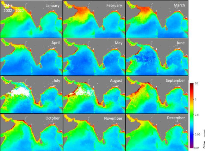
MODIS-Aqua provides satellite-derived ocean colour and SST observations that can be used to investigate marine environmental variability.
Important applications include:
- Chlorophyll-a concentration mapping.
- Monthly and seasonal phytoplankton variability.
- Spatial distribution of coastal productivity.
- Identification of potential phytoplankton bloom areas.
MODIS ocean-colour products are particularly useful for developing long-term Chl-a time series. However, suspended sediments and coloured dissolved organic matter (CDOM) in river-influenced coastal waters can interfere with standard Chl-a retrieval algorithms, potentially producing biased estimates. DOI
2. VIIRS (Visible Infrared Imaging Radiometer Suite)
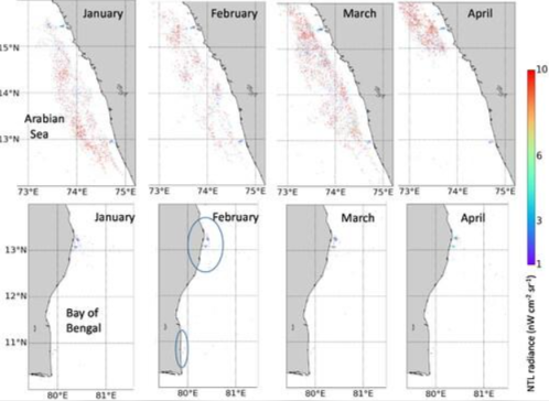
VIIRS provides valuable information about oceanographic conditions and nighttime fishing-vessel activity.
Its applications include:
- Identification of nighttime fishing-vessel clusters.
- Examination of fishing activity near thermal fronts.
- Spatial comparison between fishing intensity and Chl-a distribution.
- Investigation of the relationship between fishing activities and potential productivity hotspots.
VIIRS nighttime boat detection should be interpreted carefully because detected lights do not represent all fishing vessels or provide direct measurements of fish abundance.
3. NOAA OISST (Optimum Interpolation Sea Surface Temperature)
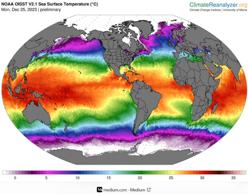
NOAA OISST provides gridded daily and long-term sea surface temperature datasets suitable for regional and global climate analysis.
Its applications include:
- Long-term SST trend assessment.
- Monthly and seasonal temperature climatology.
- Interannual SST anomaly analysis.
- Identification of unusual warming events.
- Comparison of coastal and offshore temperature patterns.
Combining NOAA OISST with MODIS observations can provide complementary information about SST variability, although differences in spatial resolution, processing methods, and temporal coverage should be considered during data integration.
Developing a satellite-based marine productivity assessment framework
An integrated geospatial framework can help transform satellite observations into practical information for fisheries planning.
The research can follow several analytical stages:
1. Data acquisition and preprocessing
Collect MODIS-Aqua Chl-a, MODIS SST, VIIRS observations, and NOAA OISST datasets for a consistent study period.
Cloud-contaminated observations, missing values, land contamination, and poor-quality pixels should be handled using appropriate quality-control procedures.
2. Seasonal composite generation
Generate monthly and seasonal mean maps to identify spatial and temporal variations in SST and Chl-a.
The Northern Bay of Bengal can be divided into coastal, continental shelf, and offshore zones for comparative analysis.
3. Statistical trend analysis
Apply linear regression, Mann–Kendall testing, and Sen’s slope estimation to investigate long-term changes.
Seasonal anomalies can also be calculated relative to a consistent multi-year climatological baseline.
4. Thermal front and productivity hotspot identification
Use SST gradient analysis and Chl-a distribution to identify oceanographic fronts and potentially productive areas.
A multi-criteria evaluation (MCE) approach may combine Chl-a suitability, thermal-front density, SST conditions, bathymetry, and seasonal persistence to develop spatial productivity-suitability maps.
5. Fisheries activity integration
Compare potential productivity hotspots with VIIRS nighttime vessel detections and available fisheries landing or catch statistics.
This can help investigate whether fishing activities are spatially associated with persistent oceanographic features.
6. Validation and uncertainty assessment
Where possible, compare satellite-derived Chl-a and SST estimates with in-situ measurements from coastal monitoring stations, research vessels, and fisheries surveys.
Special attention should be given to satellite Chl-a uncertainty in turbid and river-influenced coastal waters.
How do seasonal oceanographic changes influence marine fisheries?
Seasonal variations in SST and Chl-a can influence marine fisheries through their effects on phytoplankton production, food-web dynamics, fish habitat suitability, and the distribution of marine organisms.
In the Northern Bay of Bengal, nutrient inputs from the GBM river system, seasonal upwelling, vertical mixing, and ocean circulation contribute to spatial variations in marine productivity.
These processes can influence the distribution of commercially important species, including hilsa, sardines, anchovies, mackerels, and other pelagic and demersal fishes.
Major potential applications include:
- Identification of productive fishing areas: Mapping persistent Chl-a concentrations and oceanographic fronts can help identify potentially productive fishing grounds.
- Seasonal fishing-ground assessment: Understanding seasonal environmental changes can support the identification of periods when marine habitats may become more suitable for particular fish species.
- Fisheries habitat suitability: Combining SST, Chl-a, bathymetry, and other environmental indicators can help evaluate potential habitat conditions.
- Climate-related fisheries monitoring: Long-term SST anomalies can provide information about changing thermal conditions that may influence fish distribution and migration.
- Fishing operation planning: Integrating oceanographic information with fisheries observations could support more informed fishing-ground selection and operational planning.
Importantly, satellite-derived productivity indicators should be integrated with actual catch records and species-specific ecological information before drawing conclusions about fisheries abundance or yield.
Why does this research matter?
Bangladesh’s marine fisheries sector plays an important role in national food security, employment, export earnings, and the livelihoods of coastal communities.
However, marine productivity is not spatially uniform or temporally constant. Seasonal oceanographic changes can create different environmental conditions across coastal, shelf, and offshore waters.
Understanding these variations is essential for developing more effective fisheries monitoring and management approaches.
An integrated satellite-based assessment could contribute to:
- Identification of seasonal marine productivity hotspots.
- Improved understanding of SST and Chl-a interactions.
- Monitoring of long-term oceanographic changes.
- Identification of potential fishing zones.
- Better integration of satellite observations into fisheries management.
- Supporting climate-resilient marine fisheries planning.
- Strengthening scientific information for sustainable exploitation of marine resources.
The research could also support ecosystem-based fisheries management by connecting oceanographic observations with biological and fisheries information.
Looking ahead
Future research should focus on developing long-term satellite-based monitoring systems that combine oceanographic observations, fisheries catch information, and biological habitat assessments.
The integration of MODIS, VIIRS, and NOAA OISST with additional environmental parameters such as sea surface salinity, dissolved oxygen, mixed-layer depth, and ocean currents could provide a more comprehensive understanding of marine productivity dynamics.
Particular attention should be given to the northern coastal region, the continental shelf, and offshore waters of Bangladesh, where differences in river discharge, bathymetry, and ocean circulation may create distinct productivity patterns.
Further investigations should also examine relationships between oceanographic variability and the seasonal distribution of important commercial species, particularly hilsa and other pelagic fisheries resources.
Ultimately, developing operational satellite-based marine productivity maps could help fisheries authorities, researchers, and fishing communities access timely environmental information for improved fisheries planning.
Conclusion
Seasonal variations in sea surface temperature and chlorophyll-a concentration are important indicators of changing marine environmental conditions in the Northern Bay of Bengal.
Their interactions with monsoon circulation, freshwater discharge, nutrient availability, and oceanographic fronts influence phytoplankton dynamics and the environmental conditions supporting marine food webs.
Integrating MODIS, VIIRS, and NOAA OISST observations with GIS-based spatial analysis and fisheries information offers an effective approach to investigating these relationships.
Beyond understanding oceanographic variability, this research has practical value for identifying potential productive marine areas, monitoring changing fisheries habitats, and supporting sustainable marine resource management.
The objective is not simply to map ocean temperature and chlorophyll concentration, but to translate satellite-derived oceanographic information into meaningful scientific insights that support sustainable fisheries, climate-resilient marine resource management, and the future of Bangladesh’s blue economy.
References:
- Rouf, M. A., Antu, A. H., & Noor, M. I. (2020). Seasonal and annual variability in chlorophyll-a in the shelf region of the Northern Bay of Bengal using MODIS-Aqua data. Oceanological and Hydrobiological Studies. Read research article.
- Raju et al. (2022). Variability of the thermal front and its relationship with Chlorophyll-a in the north Bay of Bengal. Regional Studies in Marine Science. Read research article.
- (2025). A multi-criteria based optimal niche analysis of seasonal productivity in the Bay of Bengal using MODIS data. Remote Sensing Applications: Society and Environment. Read research article.
- Abin et al. (2026). Satellite-Based Modeling of Marine Productivity and Fisheries Habitat Conditions in the Northern Bay of Bengal. Fisheries Oceanography. Read research article.
- (2026). Evaluation of phytoplankton phenology in the northern Bay of Bengal using ocean color remote sensing. Read research article.