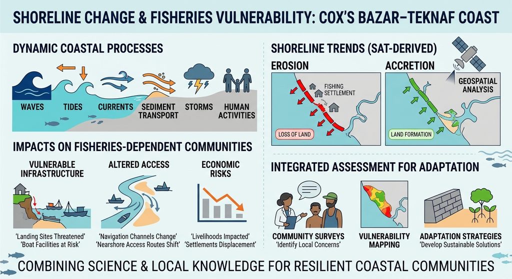
Coastal shorelines are dynamic environments shaped by waves, tides, currents, sediment transport, storms, and human activities. Along the Cox’s Bazar–Teknaf coastline of southeastern Bangladesh, these processes continuously reshape beaches, coastal settlements, river mouths, and nearshore environments. While some coastal areas experience erosion and land loss, others undergo accretion through sediment deposition, resulting in the formation or expansion of coastal landforms.
These changes are particularly important for Bangladesh because coastal communities depend heavily on marine fisheries, small-scale fishing operations, fish landing centres, boat facilities, and related economic activities. Shoreline movement can affect the accessibility, safety, and long-term functionality of fisheries infrastructure. Erosion may threaten landing sites, fishing settlements, roads, and storage facilities, while accretion can alter navigation channels, nearshore access routes, and the location of suitable landing areas.
The Cox’s Bazar–Teknaf coast therefore requires an integrated assessment of shoreline change and its implications for fisheries-dependent communities. By combining satellite-derived shoreline information, geospatial analysis, and community surveys, researchers can identify vulnerable locations and develop evidence-based strategies for coastal adaptation.
Why Is Shoreline Change Important?
Shoreline erosion and accretion are natural coastal processes, but their impacts become increasingly significant when they affect human settlements and economic infrastructure.
Coastal erosion occurs when waves, currents, storms, and other processes remove sediment from the shoreline. Persistent erosion can reduce beach width, damage coastal vegetation, expose settlements, and threaten roads and infrastructure.
Coastal accretion occurs when sediment accumulates along the coast, resulting in shoreline advancement or the formation of new coastal land. Although accretion can create additional land, it may also change drainage patterns, tidal channels, and navigation conditions.
For fisheries-dependent communities, both processes can create challenges. Erosion can damage fish landing facilities, boat storage areas, access roads, and nearby settlements. Accretion can shift the shoreline away from existing landing facilities or create shallow areas that make boat movement more difficult.
Understanding the direction, magnitude, and spatial distribution of shoreline changes is therefore essential for protecting coastal livelihoods and maintaining functional fisheries infrastructure.
Current Situation Along the Cox’s Bazar–Teknaf Coast
The Cox’s Bazar–Teknaf coastal zone is an important geographical and economic region of Bangladesh. Its coastline includes sandy beaches, coastal settlements, estuarine environments, and areas influenced by tidal and marine processes.
The region supports fishing activities ranging from small-scale artisanal operations to larger commercial fishing-related activities. Fish landing locations, boat movement routes, coastal markets, and transportation facilities are closely connected to shoreline conditions.
However, the coastline is not geographically stable. Seasonal wave conditions, monsoon-driven processes, cyclonic disturbances, sediment transport, and local human interventions can influence shoreline position. The intensity and direction of change may also vary between individual coastal segments.
A single observation cannot adequately describe these long-term dynamics. Some locations may experience persistent erosion, while others may show accretion or alternating periods of shoreline retreat and advancement.
Despite the importance of this coastline, a systematic assessment connecting historical shoreline changes with the vulnerability of fisheries infrastructure and fishing communities remains valuable. Identifying where shoreline movement overlaps with important fisheries facilities can help translate coastal monitoring into practical management decisions.
Scientific Assessment: Integrating Satellite Data and Community Surveys
A comprehensive investigation of shoreline dynamics along the Cox’s Bazar–Teknaf coast can be developed through the integration of remote sensing, geographic information systems (GIS), shoreline-change statistics, and community-based observations.
1. Satellite-Based Shoreline Extraction
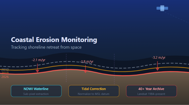
Historical Landsat imagery can provide a long-term record of coastal changes, while Sentinel-2 imagery can support more detailed analysis of recent shoreline conditions. A suitable study could use cloud-free images from multiple years, preferably selected from comparable seasons and tidal conditions.
Water indices such as the Normalized Difference Water Index (NDWI) and Modified Normalized Difference Water Index (MNDWI) can help distinguish land from water. The extracted shoreline boundaries should then be checked and corrected using visual interpretation, particularly in areas with wet sand, tidal flats, vegetation, and river-mouth environments.
Using consistent image-selection and shoreline-extraction procedures is essential because tidal variation, seasonal beach changes, and image resolution can influence the apparent shoreline position.
2. Digital Shoreline Analysis System (DSAS)
The Digital Shoreline Analysis System (DSAS) can be used to quantify shoreline movement through a series of transects generated along a reference baseline.
Important statistical indicators include:
- Shoreline Change Envelope (SCE): Measures the total range of shoreline movement.
- Net Shoreline Movement (NSM): Measures the distance between the oldest and most recent shoreline positions.
- End Point Rate (EPR): Calculates the rate of shoreline movement between two dates.
- Linear Regression Rate (LRR): Estimates the long-term rate of shoreline change using multiple shoreline positions.
Positive and negative values can be used to distinguish accretion and erosion according to the adopted transect orientation and DSAS convention. These measurements can help identify erosion hotspots, accretion zones, and coastal segments experiencing relatively stable conditions.
3. Assessment of Fisheries Infrastructure
Shoreline-change maps should be integrated with spatial information on fisheries-related infrastructure. Relevant features may include:
- Fish landing centres and landing points.
- Boat anchoring and mooring locations.
- Fishing-boat repair and storage facilities.
- Fish markets, ice plants, and processing facilities.
- Coastal access roads and transportation networks.
- Fishing settlements and associated service facilities.
By comparing infrastructure locations with historical and recent shoreline positions, researchers can identify facilities potentially exposed to erosion, shoreline displacement, or changing coastal access conditions.
4. Community-Based Surveys
Satellite observations alone cannot explain all the socioeconomic consequences of shoreline change. Community surveys are therefore essential for understanding how coastal changes affect fishing activities and local livelihoods.
Structured questionnaires, key informant interviews, and focus group discussions can be conducted with fishers, boat owners, fish traders, landing-centre workers, and local community representatives.
The surveys may investigate changes in landing locations, boat accessibility, fishing operations, infrastructure damage, transportation costs, livelihood adjustments, and perceptions of coastal hazards.
Combining community observations with satellite-derived evidence can help validate local changes and identify impacts that are not directly visible in satellite imagery.
Potential Impacts on Fisheries Infrastructure and Fishing Communities
1. Vulnerability of Fish Landing Facilities
Fish landing locations are closely connected to shoreline position and coastal accessibility. Persistent erosion may threaten landing platforms, nearby roads, storage facilities, and other supporting infrastructure.
Where accretion occurs, sediment accumulation may change water depth and access conditions. Existing landing facilities may become less suitable if shoreline movement changes the distance between landing points and navigable water.
2. Changes in Fishing Operations
Shoreline transformation can influence where fishing boats are launched, anchored, repaired, and brought ashore. Changes in coastal access may require fishers to use alternative landing locations or travel longer distances to reach suitable facilities.
Such adjustments can increase operational expenses and create additional challenges for small-scale fishers who have limited financial resources.
3. Impacts on Coastal Settlements and Livelihoods
Fishing communities often depend on coastal land for housing, boat storage, net preparation, fish handling, and small-scale trading activities. Shoreline erosion can threaten these interconnected activities and increase the risk of damage to household assets.
The consequences may extend beyond fishers to fish traders, transport workers, processing workers, and other people whose incomes depend on fisheries-related activities.
4. Accretion and Changing Coastal Access
Accretion is not necessarily beneficial in every situation. Sediment deposition can alter tidal channels, create shallow areas, and change the accessibility of coastal waterways.
For fishing communities, these changes may affect boat movement, landing-site selection, and the suitability of existing infrastructure. Therefore, both erosion and accretion should be considered in coastal development planning.
Management Strategies and Practical Applications
An integrated shoreline assessment can provide important information for coastal adaptation and fisheries infrastructure planning.
1. Establishing a Shoreline Monitoring System
Regular Landsat and Sentinel-2 analysis can support long-term monitoring of coastal change. Updated shoreline maps can help identify emerging erosion hotspots and areas experiencing significant accretion.
2. Risk-Based Fisheries Infrastructure Planning
New fish landing facilities, boat storage areas, ice plants, and fish markets should be planned with consideration of historical shoreline movement, local geomorphology, coastal hazards, and future exposure.
3. Protecting Existing Infrastructure
Infrastructure located in erosion-prone areas may require appropriate protective measures following site-specific environmental and engineering assessments. Possible approaches include properly designed coastal protection structures, beach nourishment where technically suitable, and nature-based measures where local conditions support them.
4. Community Participation in Coastal Adaptation
Fishers and local stakeholders should be involved in identifying vulnerable locations, reporting infrastructure damage, and evaluating adaptation measures. Their knowledge can improve the accuracy and practical relevance of coastal management decisions.
5. Integrating GIS-Based Vulnerability Mapping
A coastal vulnerability map can be developed by combining shoreline-change rates, infrastructure locations, settlement distribution, coastal exposure, and community survey findings. Such a map can help authorities prioritize locations for monitoring, protection, and infrastructure investment.
Why Does This Research Matter?
Shoreline change is not simply a geographical issue; it is directly connected to the sustainability of coastal fisheries and the wellbeing of fishing-dependent communities.
For the Cox’s Bazar–Teknaf coast, understanding the relationship between shoreline movement and fisheries infrastructure can help answer several important questions:
- Which fish landing locations are experiencing the greatest shoreline changes?
- Where are fishing-related facilities most exposed to coastal erosion?
- How is accretion changing boat accessibility and coastal navigation?
- Which communities may require priority support for adaptation?
- Where should future fisheries infrastructure be developed to reduce long-term risk?
The proposed research would connect physical coastal processes with practical fisheries management. This is particularly important because infrastructure development without considering shoreline dynamics may result in repeated damage, additional maintenance costs, and long-term economic losses.
Looking Ahead: Toward Climate-Resilient Fisheries Infrastructure
Future coastal planning in Bangladesh should move beyond considering erosion as an isolated environmental problem. Instead, shoreline dynamics should be incorporated into fisheries development, coastal transportation, settlement planning, and disaster-risk management.
An integrated monitoring framework combining Landsat, Sentinel-2, DSAS, GIS, and community surveys could provide a practical foundation for this approach. Historical satellite records would reveal long-term shoreline trends, while recent imagery and field observations would help identify emerging changes.
More importantly, linking these results with fisheries infrastructure and socioeconomic information could support the development of location-specific adaptation strategies. Local authorities, fisheries agencies, coastal planners, and community organizations could use these findings to prioritize infrastructure investment and improve preparedness.
Conclusion
The Cox’s Bazar–Teknaf coastline represents an important natural and economic landscape for Bangladesh. Its changing shoreline has implications that extend beyond coastal geomorphology, influencing fisheries infrastructure, fishing operations, and the livelihoods of coastal communities.
By integrating satellite remote sensing, DSAS-based shoreline analysis, and community-level assessments, researchers can develop a clearer understanding of where erosion and accretion are occurring and how these processes affect fisheries-dependent populations.
Ultimately, sustainable fisheries development requires infrastructure that can respond to changing coastal conditions. Understanding shoreline dynamics today can help Bangladesh build safer, more resilient, and better-planned coastal fisheries systems for the future.
Research Perspective
This article presents a research framework rather than reporting new field measurements. A dedicated investigation should establish its own study period, shoreline extraction procedures, DSAS transect configuration, infrastructure inventory, and community survey dataset before reporting site-specific erosion rates or socioeconomic impacts.
Selected Scientific and Institutional References
1. Beach morphology, textural variation and erosion along the south-eastern coastal segment in Cox’s Bazar-Teknaf, Bangladesh. (2025). Journal of Sea Research, 205, 102579. Read the study.
2. Shoreline dynamics in response to sea-level changes on the eastern coast of Bangladesh. (2025). Environmental Monitoring and Assessment. Read the study.
3. Shoreline Change around a River Delta on the Cox’s Bazar Coast of Bangladesh. (2018). Journal of Marine Science and Engineering, 6(3), 80. Read the study.
4. Matin, N., & Hasan, G. M. J. (2021). A quantitative analysis of shoreline changes along the coast of Bangladesh using remote sensing and GIS techniques. CATENA, 201, 105185. Read the study.
5. Japan International Cooperation Agency (JICA). Study report on coastal conditions and shoreline changes in Cox’s Bazar and Teknaf. View the report.
6. Centre for Natural Resource Studies (CNRS). Cox’s Bazar synthesis report. View the report.