Understanding changing marine environments, identifying shifting fishing grounds, and developing climate-responsive fisheries management strategies
Climate change is increasingly influencing marine ecosystems by altering ocean temperature, circulation patterns, biological productivity, and the geographical distribution of suitable fish habitats. These environmental changes are particularly important in the Bay of Bengal, where millions of people depend on marine fisheries for food security, employment, and livelihoods.
The Bay of Bengal is a highly dynamic marine ecosystem influenced by seasonal monsoon circulation, freshwater discharge, coastal processes, and interactions between different oceanographic systems. Changes in these processes may influence the distribution of nutrients, plankton, and commercially important fish species, potentially modifying the location and seasonal accessibility of productive fishing grounds.
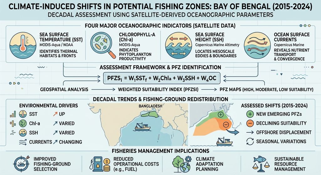
Satellite remote sensing provides an opportunity to monitor these changes over large geographical areas. By integrating sea surface temperature (SST), chlorophyll-a concentration, sea surface height (SSH), and ocean surface currents, researchers can investigate environmental conditions associated with potential fishing grounds and examine how their geographical distribution changes over time.
This research focuses on a decadal assessment of Potential Fishing Zones (PFZs) across the Bay of Bengal during 2015–2024. The study aims to investigate changing oceanographic conditions, identify potential shifts in fishing-ground suitability, and develop a satellite-based framework to support more efficient and climate-responsive marine fisheries management.
Why are Potential Fishing Zones important?
Potential Fishing Zones represent marine areas where combinations of oceanographic and biological conditions may be favourable for fish occurrence and aggregation.
Fish distribution is strongly influenced by environmental conditions, particularly temperature, food availability, ocean circulation, and habitat characteristics. Understanding these factors can help identify locations where fishing activities may be more productive.
Traditionally, fishing-ground identification has relied heavily on fishermen’s experience, historical catch information, and seasonal knowledge. Although these approaches remain valuable, changing oceanographic conditions may influence the reliability of historically established fishing locations.
Satellite-derived environmental information offers an additional scientific approach to understanding these changes.
Four important parameters are particularly relevant:
- Sea Surface Temperature (SST): Helps identify thermal habitats, temperature gradients, and oceanic fronts that may influence fish distribution.
- Chlorophyll-a (Chl-a): Provides an indicator of phytoplankton biomass and surface primary productivity, helping identify potentially productive marine environments.
- Sea Surface Height (SSH): Helps identify mesoscale oceanographic structures, including cyclonic and anticyclonic eddies, which can influence nutrient transport and marine productivity.
- Ocean Surface Currents: Provide information about water movement, convergence, divergence, and the redistribution of nutrients and plankton.
Combining these parameters can provide a more comprehensive understanding of potential fishing-ground suitability than relying on SST or chlorophyll-a independently.
Why is the Bay of Bengal attracting attention?
The Bay of Bengal is one of the most important marine ecosystems in the northern Indian Ocean. It supports diverse fisheries and provides essential resources for coastal communities across Bangladesh, India, Myanmar, and neighbouring countries.
Its oceanographic environment is characterised by strong seasonal variability. The southwest and northeast monsoons influence surface circulation, while freshwater discharge from the Ganges–Brahmaputra–Meghna river system affects coastal salinity, turbidity, nutrient availability, and biological productivity.
These interactions create distinct environmental conditions across coastal, continental shelf, and offshore waters.
Climate change introduces additional challenges by modifying ocean temperature patterns, circulation dynamics, and marine ecosystem processes. Increasing temperatures may influence the thermal preferences of fish species, while changing circulation patterns may alter nutrient distribution and the availability of suitable feeding environments.
As a result, some traditionally productive fishing areas may experience changes in environmental suitability, while other locations may become relatively more favourable.
Understanding whether these changes are occurring, where they are taking place, and how they vary seasonally is essential for developing climate-resilient fisheries management strategies.
Assessing decadal fishing-ground changes using satellite remote sensing
An important component of this research is the integration of satellite-derived oceanographic observations to investigate changes in PFZ suitability across the Bay of Bengal.
The proposed assessment covers the 2015–2024 period and incorporates satellite and oceanographic datasets from NASA, NOAA, and Copernicus Marine.
The analysis focuses on four major environmental indicators.
1. Sea Surface Temperature and thermal-front variability
Satellite-derived SST observations will be used to examine seasonal and long-term temperature variations. Particular attention will be given to thermal fronts, which represent boundaries between water masses with different temperatures.
These fronts may influence nutrient distribution, plankton aggregation, and fish feeding opportunities.
Raju et al. (2022) investigated thermal-front variability and its relationship with chlorophyll-a distribution in the northern Bay of Bengal. Their research highlights the importance of thermal-front monitoring in understanding oceanographic conditions associated with fishing activity.
2. Chlorophyll-a and biological productivity
MODIS-Aqua ocean-colour observations will be used to examine spatial and temporal variations in chlorophyll-a concentration.
The assessment will investigate coastal and offshore productivity differences, seasonal changes, and the persistence of high-chlorophyll regions.
These observations can help identify areas where environmental conditions may support greater primary productivity and potentially favourable marine food-web conditions.
However, chlorophyll-a concentration is not a direct measurement of fish abundance. Its relationship with fish distribution depends on food-web interactions, species ecology, and biological response times.
3. Sea Surface Height and mesoscale eddies
Satellite altimetry observations will be used to identify changes in sea-level anomaly and mesoscale oceanographic structures.
Cyclonic eddies may promote upward nutrient transport under suitable conditions, potentially supporting phytoplankton productivity. Other circulation structures may influence the distribution and aggregation of marine organisms through different physical processes.
Investigating these features can help explain why certain fishing-ground locations may remain productive or experience changes over time.
4. Ocean currents and marine resource redistribution
Ocean surface currents influence the movement of nutrients, plankton, fish larvae, and other biological materials.
Seasonal changes in current velocity and direction may modify the distribution of productive water masses and create convergence or divergence zones.
Integrating current information with SST, chlorophyll-a, and SSH can provide additional insight into the dynamic nature of potential fishing grounds.
What could climate-induced fishing-ground shifts mean for Bangladesh?
Changes in potential fishing-ground distribution could have important implications for Bangladesh’s marine fisheries and coastal fishing communities.
If environmental conditions become less favourable in traditionally productive locations, fishing vessels may need to travel farther to identify suitable fishing grounds. This could increase fuel consumption, fishing time, operational expenses, and exposure to adverse weather conditions.
Small-scale fishing communities may be particularly vulnerable because they often have limited access to advanced navigation systems, real-time oceanographic information, and modern fishing technologies.
Several important questions therefore emerge:
- Are traditionally productive fishing areas experiencing changes in environmental suitability?
- Are potential fishing hotspots becoming more concentrated in offshore waters?
- How are seasonal temperature and productivity changes influencing fishing-ground locations?
- Are oceanographic changes associated with variations in fish catch and fishing efficiency?
- Can satellite-based monitoring help fishermen anticipate changes in fishing-ground availability?
A 2025 study by Makwana and Patnaik, published in Marine Environmental Research, investigated the relationship between extreme climate events, sea surface temperature indicators, and the vulnerability of marine pelagic fisheries in the Bay of Bengal region. Their findings highlighted the importance of considering ocean warming and climate-related disturbances when evaluating fisheries vulnerability.
Similarly, research by Aziz (2025) examined relationships between marine fish production and climatic and oceanographic variables along the Cox’s Bazar coast, Bangladesh.
These studies demonstrate the importance of connecting satellite-derived environmental information with actual fisheries production and climate vulnerability assessments.
Developing a satellite-based fishing-ground monitoring framework
An important objective of this research is to establish an integrated geospatial framework capable of identifying and monitoring changes in potential fishing-ground suitability over time.
The proposed assessment will combine four environmental parameters through a multi-parameter Potential Fishing Zone Suitability Index (PFZSI).
The index will integrate:
- Thermal-front characteristics derived from SST.
- Biological productivity indicators derived from chlorophyll-a.
- Mesoscale oceanographic features derived from SSH.
- Current-associated circulation characteristics.
Each parameter will be normalised and integrated using scientifically justified weights. The resulting suitability maps will distinguish relatively high, moderate, and low environmental suitability.
Annual and seasonal maps will then be compared to investigate the geographical redistribution of potential fishing grounds.
The assessment will also use statistical approaches, including the Mann–Kendall trend test and Sen’s slope estimator, to investigate long-term environmental trends.
Importantly, the study will distinguish between changes in environmental suitability and actual changes in fish distribution. Where fisheries observations are available, predicted PFZs will be evaluated against catch per unit effort (CPUE), fishing-vessel locations, and species-specific catch records.
This validation is essential because environmentally favourable areas do not necessarily contain higher fish abundance.
Developing practical applications for fishermen and fisheries management
The findings of this research could contribute to several practical applications in Bangladesh’s marine fisheries sector.
1. Climate-responsive fishing advisories
Satellite-derived PFZ maps could help fishermen identify potentially favourable fishing areas based on updated oceanographic conditions rather than depending exclusively on historical fishing locations.
2. Improved fishing-ground selection
Combining SST, chlorophyll-a, SSH, and ocean-current information may improve the identification of potential fishing hotspots and help reduce unnecessary searching.
3. Reduction of operational costs
More informed fishing-ground selection could potentially reduce travel distances, fuel consumption, and fishing time. Actual economic benefits would require field-based evaluation.
4. Identification of changing productivity hotspots
Long-term PFZ monitoring could help identify areas where environmental suitability is increasing, decreasing, or remaining relatively stable.
5. Sustainable fisheries management
Information about persistent productive regions could support fisheries monitoring, ecosystem-based management, habitat protection, and the development of climate adaptation strategies.
6. Development of digital PFZ advisory systems
Combining satellite observations, GIS, and predictive modelling could eventually support near-real-time fishing advisories accessible through digital platforms.
Such systems could be particularly valuable for coastal fishing communities that have limited access to advanced oceanographic information.
Why does this research matter?
Bangladesh’s marine fisheries are an important component of national food security, employment, economic development, and the blue economy.
However, fisheries productivity depends not only on fish populations and fishing pressure but also on the environmental conditions that support marine ecosystems.
Climate-induced changes in ocean temperature, biological productivity, and circulation may influence the availability and geographical distribution of marine resources.
Understanding these changes before they become major management challenges is essential for developing adaptive fisheries strategies.
A decadal assessment provides an opportunity to investigate whether potentially productive fishing areas are experiencing persistent environmental changes rather than relying on individual satellite observations or short-term environmental variations.
Furthermore, integrating remote sensing with fisheries observations can help bridge the gap between oceanographic research and practical fishing operations.
The research is therefore relevant not only to marine scientists but also to fisheries managers, policymakers, coastal communities, and institutions working towards sustainable marine resource utilisation.
Looking ahead
The proposed research aims to provide a stronger understanding of how changing oceanographic conditions may influence potential fishing-ground distribution across the Bay of Bengal.
Several important questions remain to be investigated. These include the magnitude and direction of long-term SST changes, the persistence of high-chlorophyll regions, the redistribution of mesoscale oceanographic features, and the extent to which these environmental changes correspond with observed fisheries performance.
Further research should also incorporate species-specific ecological information because commercially important pelagic and demersal fish species may respond differently to changing oceanographic conditions.
Future developments could include machine-learning models such as Random Forest, XGBoost, and ConvLSTM to improve the prediction of dynamic fishing-ground locations using historical and near-real-time satellite observations.
Collaboration between remote-sensing researchers, marine biologists, fisheries scientists, and fishing communities will be particularly important for validating these predictive systems and translating scientific findings into practical applications.
Ultimately, the integration of satellite remote sensing, oceanographic analysis, and fisheries data could contribute to a more adaptive approach to marine fisheries management in Bangladesh.
The objective is not simply to identify where fish might be found, but to understand how changing ocean conditions may reshape fishing opportunities, improve fishermen’s decision-making, and support the long-term sustainability of the Bay of Bengal’s marine resources.