Tropical coastal ecosystems are among the most productive and biologically diverse marine environments. They support important fisheries, coral communities, seagrass beds, mangrove-associated habitats, and numerous commercially valuable aquatic species. However, these ecosystems are increasingly exposed to environmental pressures, including coastal pollution, eutrophication, habitat degradation, rising sea temperatures, sedimentation, and climate variability.
Monitoring these changes is essential for understanding marine ecosystem health and maintaining sustainable fisheries. Traditional monitoring approaches generally depend on research vessels, laboratory-based water analysis, divers, and fixed monitoring stations. Although these methods provide valuable information, they may be limited by high operational costs, restricted sampling frequency, difficult access to certain locations, and challenges in observing rapid environmental changes.
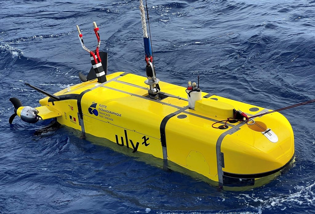
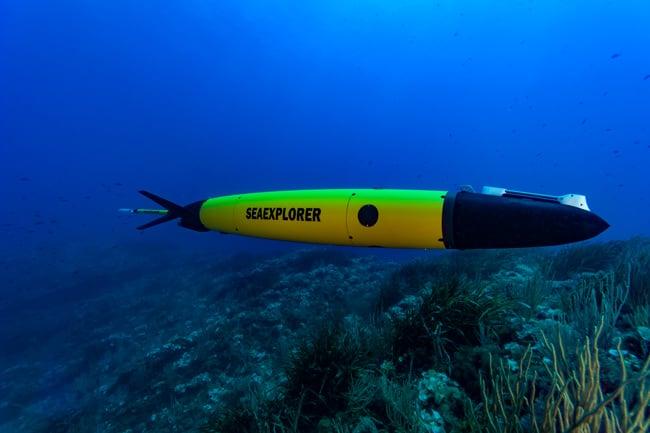
Autonomous Underwater Vehicles (AUVs) offer an emerging technological approach to addressing these limitations. These battery-powered, self-propelled underwater platforms can follow pre-programmed routes, collect environmental measurements, and survey underwater habitats with limited direct human intervention. Equipped with advanced sensors, cameras, acoustic instruments, and navigation systems, AUVs can support repeated monitoring of marine water quality and fish habitat conditions.
Their application in tropical coastal ecosystems could provide valuable opportunities for improving environmental surveillance, identifying ecological changes, and supporting science-based fisheries management.
Why Are Autonomous Underwater Vehicles Important?
Marine ecosystems are highly dynamic, and environmental conditions can change considerably across different depths, locations, and seasons. A water-quality measurement collected at the surface may not represent conditions near the seabed or within deeper water layers.
AUVs can address this limitation by collecting spatially distributed and depth-specific environmental information. Unlike conventional sampling at fixed stations, an AUV can travel along planned underwater transects and measure multiple environmental parameters during a single mission.
Their importance can be understood through several applications:
- Repeated environmental monitoring: AUVs can follow predefined survey routes to compare environmental conditions over time.
- Depth-resolved measurements: They can collect water-quality information at different depths, helping identify stratification and oxygen-depleted layers.
- Underwater habitat assessment: Cameras and acoustic sensors can document seabed characteristics, vegetation, coral structures, and other habitat features.
- Early detection of environmental changes: Sensor measurements can help identify unusual temperature, turbidity, dissolved oxygen, or chlorophyll-a conditions.
- Access to difficult environments: AUVs can survey selected underwater areas that may be challenging or costly for conventional research operations.
Importantly, AUVs do not necessarily provide uninterrupted, real-time monitoring. Most systems operate through scheduled autonomous missions, with data stored onboard or transmitted through suitable communication arrangements. Nevertheless, repeated missions and integration with other monitoring platforms can create a near-continuous environmental observation framework.
Current Situation and Opportunities in Tropical Coastal Ecosystems
Tropical coastal environments experience complex interactions between freshwater discharge, tidal circulation, sediment transport, biological productivity, and human activities. These interactions can create significant spatial and seasonal variations in marine water quality.
In Bangladesh, the northern Bay of Bengal, the Cox’s Bazar–Teknaf coastline, the Saint Martin’s Island region, and other coastal and estuarine environments provide important opportunities for advanced underwater monitoring.
These ecosystems support fisheries and marine biodiversity but are also influenced by coastal development, riverine inputs, fishing activities, sedimentation, and changing climatic conditions.
Conventional sampling can provide important baseline information, but frequent measurements across multiple depths and locations may require considerable logistical resources. AUV-based monitoring could complement these approaches by collecting repeated observations along selected coastal transects.
For example, an AUV operating around Saint Martin’s Island could be programmed to survey selected nearshore areas and collect temperature, salinity, dissolved oxygen, turbidity, and chlorophyll-a fluorescence measurements. Underwater cameras and acoustic instruments could simultaneously document habitat characteristics and fish presence.
Such an approach would help researchers investigate relationships between changing environmental conditions and the distribution of marine habitats and aquatic organisms.
However, the successful application of AUVs in Bangladesh would require appropriate vehicle selection, sensor calibration, navigation planning, field validation, and consideration of local water depth, currents, turbidity, and operational conditions.
Scientific Assessment: Integrating AUVs and Environmental Monitoring Technologies
A comprehensive AUV-based monitoring framework can be developed by combining underwater robotics, multiparameter sensors, underwater imaging, acoustic technologies, and geospatial data analysis.
1. AUV Platform and Navigation System
An AUV generally consists of a waterproof body, propulsion system, battery, navigation equipment, onboard computer, communication system, and scientific sensor payload.
Its navigation system may combine inertial measurement units, depth sensors, Doppler Velocity Logs (DVL), compasses, and acoustic positioning technologies.
Researchers can program the vehicle to follow predefined transects, survey specific depths, or investigate selected areas of ecological importance.
Because conventional GPS signals cannot directly provide underwater positioning, AUVs generally rely on underwater navigation systems and obtain GPS positioning when surfaced or through suitable acoustic positioning arrangements.
2. Multiparameter Water-Quality Monitoring
AUVs can carry different environmental sensors to measure important physical, chemical, and biological indicators.
Key monitoring parameters include:
- Water temperature: Helps identify thermal variation, seasonal warming, and water-column stratification.
- Salinity: Provides information about freshwater influence, coastal circulation, and water-mass distribution.
- Dissolved oxygen (DO): Helps identify oxygen depletion and environmental conditions that may affect aquatic organisms.
- pH: Supports assessment of marine carbonate chemistry and potential acidification-related changes.
- Turbidity: Indicates suspended particles and changes in underwater visibility.
- Chlorophyll-a fluorescence: Provides an optical estimate of phytoplankton biomass and helps identify areas of elevated biological productivity.
- Conductivity: Supports salinity estimation and water-mass characterization.
Combining these measurements can provide a more detailed understanding of marine environmental conditions than relying on a single water-quality indicator.
3. Fish Habitat and Underwater Biodiversity Assessment
Monitoring water quality alone cannot fully explain the ecological condition of a marine ecosystem. Habitat characteristics and biological observations are equally important for understanding fish distribution and habitat suitability.
AUVs can be equipped with underwater cameras, multibeam sonar, side-scan sonar, and other acoustic instruments to investigate underwater habitat conditions.
These technologies can support:
- Mapping of seabed topography and habitat structures.
- Identification of selected coral, rocky, or other structured habitats.
- Observation of fish presence and distribution along survey routes.
- Assessment of underwater vegetation and habitat complexity.
- Documentation of habitat degradation and physical disturbance.
Acoustic systems can help detect fish schools and characterize underwater structures, while optical cameras can provide visual evidence of organisms and habitat conditions.
However, fish abundance estimates from acoustic observations require appropriate calibration and, where possible, validation through complementary sampling methods.
4. Integration of Artificial Intelligence and Machine Learning
The large volume of environmental and image-based information collected by AUVs creates opportunities for automated data processing.
Machine learning algorithms can be applied to identify patterns in environmental measurements, classify underwater images, and detect unusual ecological conditions.
For example, computer vision models may help identify fish, distinguish habitat types, and assess changes in coral or seagrass conditions. Anomaly-detection algorithms could identify unusual combinations of temperature, dissolved oxygen, and turbidity that require further investigation.
By integrating sensor measurements with machine learning, researchers could develop predictive models for environmental risk assessment and habitat monitoring.
Nevertheless, reliable model performance depends on representative training datasets, appropriate validation, and careful consideration of local ecological conditions.
5. GIS-Based Environmental Mapping
Geospatial analysis can transform AUV observations into useful environmental information.
Recorded measurements can be associated with geographic coordinates and water depth to develop spatial maps of temperature, salinity, dissolved oxygen, turbidity, and chlorophyll-a.
These datasets can also be integrated with satellite observations, oceanographic information, and field measurements to examine broader environmental patterns.
For Bangladesh, combining AUV-derived observations with satellite-based sea surface temperature, chlorophyll-a, and coastal water-quality information could improve understanding of marine ecosystem variability.
Potential Applications in Fisheries and Marine Ecosystem Management
1. Monitoring Fish Habitat Conditions
Fish distribution is influenced by several environmental and habitat-related factors, including temperature, dissolved oxygen, salinity, food availability, water depth, and habitat structure.
AUV-based observations could help identify areas where environmental conditions change significantly and investigate how these changes relate to the distribution of selected fish species.
This information could contribute to habitat suitability assessment and the identification of ecologically important marine areas.
2. Early Detection of Water-Quality Problems
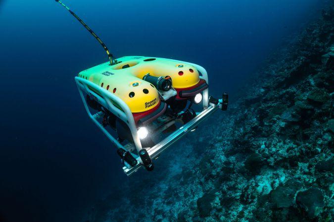
Rapid changes in dissolved oxygen, turbidity, temperature, or chlorophyll-a may indicate developing environmental problems.
Repeated AUV missions could help detect unusual conditions and identify locations requiring additional sampling or management attention.
For example, a sudden decline in dissolved oxygen near a coastal habitat may indicate an emerging oxygen-stress condition. Additional investigation could then determine its causes and potential ecological consequences.
3. Monitoring Coral and Seagrass Habitats
Coral reefs and seagrass ecosystems provide important habitat and feeding grounds for numerous marine organisms.
AUVs equipped with imaging and acoustic systems can support repeated surveys of habitat structure and condition. These observations may help researchers identify physical disturbances, changes in vegetation coverage, and selected indicators of habitat degradation.
Such applications are particularly relevant to tropical marine environments where biodiversity conservation and fisheries sustainability are closely connected.
4. Supporting Sustainable Fisheries Management
Understanding the relationship between environmental conditions and fish habitats is important for ecosystem-based fisheries management.
AUV observations could provide supplementary information for identifying habitat-sensitive areas, monitoring ecological changes, and assessing the environmental conditions associated with fisheries resources.
When integrated with fisheries surveys, acoustic observations, and biological sampling, these data could contribute to more informed fisheries planning.
5. Monitoring Marine Pollution
AUVs can help investigate the spatial distribution of selected pollution-related indicators, including turbidity, temperature anomalies, and other measurable environmental parameters.
Specialized payloads may also be designed for targeted chemical measurements or water sampling.
However, conventional environmental sensors cannot directly identify every pollutant. Heavy metals, pesticides, petroleum compounds, and microplastics generally require specialized analytical methods and laboratory confirmation.
Therefore, AUVs should be considered part of an integrated pollution-monitoring system rather than a complete replacement for laboratory-based environmental analysis.
Challenges and Limitations of AUV-Based Monitoring
Despite their potential, AUVs face several technical and operational challenges, particularly in tropical coastal environments.
1. High Initial Investment: Advanced underwater vehicles, scientific sensors, navigation systems, and maintenance facilities can require substantial financial resources.
2. Underwater Communication Limitations: Radio-frequency and conventional GPS signals do not travel effectively underwater. Acoustic communication is commonly used, but it has limitations in bandwidth, range, and reliability.
3. Battery and Mission Duration: Most battery-powered AUVs have limited operating time. Mission duration depends on vehicle design, speed, payload, environmental conditions, and energy consumption.
4. Complex Coastal Conditions: Strong currents, waves, shallow water, suspended sediments, and underwater obstacles can complicate navigation and data collection.
5. Sensor Calibration and Data Quality: Environmental sensors require regular calibration, cleaning, and validation to ensure reliable measurements. Biofouling can particularly affect optical and chemical sensors during extended deployments.
6. Data Processing and Technical Expertise: AUV operations require specialized knowledge in robotics, marine science, electronics, navigation, and data analysis.
Addressing these limitations through modular system design, local technical capacity development, appropriate mission planning, and collaboration between marine scientists and engineering institutions will be important for wider implementation.
Management Strategies and Practical Applications
The application of AUV technology in tropical coastal ecosystems should be developed through an integrated monitoring strategy.
1. Establishing Autonomous Marine Monitoring Routes
Selected coastal and marine locations could be assigned predefined underwater survey routes. Repeated missions would allow researchers to compare environmental measurements across seasons and identify long-term changes.
2. Integrating AUVs with Fixed Monitoring Stations
AUVs could complement existing monitoring buoys and fixed sensor stations. Fixed stations would provide continuous measurements at specific locations, while AUVs would collect spatially distributed observations across wider areas.
3. Developing AUV-Based Marine Habitat Databases
Environmental measurements, underwater images, acoustic records, and habitat maps could be organized into a geospatial database. Such a system would support long-term marine ecosystem assessment.
4. Strengthening Research and Institutional Collaboration
Marine science institutions, fisheries universities, oceanographic research organizations, and engineering departments could collaborate to develop locally suitable AUV platforms and sensor systems.
5. Integrating Monitoring Results into Fisheries Management
AUV-derived environmental and habitat information could be combined with fisheries statistics, biological surveys, and satellite observations to support marine spatial planning, habitat conservation, and ecosystem-based fisheries management.
Why Does This Research Matter?
The health of tropical coastal ecosystems depends on the interaction between water quality, habitat structure, biological communities, and human activities. Monitoring these components independently may not provide a complete understanding of ecosystem conditions.
AUV technology offers an opportunity to connect these different aspects through repeated, depth-specific, and spatially distributed observations.
For Bangladesh, this research direction could contribute to answering important questions:
- How do water-quality conditions vary across different depths and coastal locations?
- Where do low dissolved oxygen and unusual turbidity conditions occur?
- How are environmental changes associated with the distribution of fish habitats?
- Can repeated autonomous surveys improve the detection of ecological disturbances?
- How can underwater monitoring data support marine protected area management and sustainable fisheries planning?
By addressing these questions, AUV-based research could strengthen the scientific foundation for marine environmental monitoring and fisheries resource management.
Looking Ahead: Toward Intelligent and Autonomous Marine Monitoring
The future of marine environmental monitoring is likely to involve the integration of autonomous vehicles, artificial intelligence, Internet of Things (IoT) technologies, satellite remote sensing, and advanced oceanographic sensors.
A particularly promising approach is the development of coordinated monitoring systems involving Autonomous Underwater Vehicles, Autonomous Surface Vehicles, fixed monitoring stations, and satellite-based observations.
In such a framework, surface platforms could support communication and navigation, while underwater vehicles collect detailed environmental and habitat information. Artificial intelligence could assist in processing the collected datasets and identifying unusual environmental conditions.
For Bangladesh, a gradual research and development programme could begin with a small AUV equipped with temperature, salinity, dissolved oxygen, turbidity, and chlorophyll-a sensors. Initial field trials could be conducted in suitable coastal waters before expanding to more complex marine habitats.
The long-term objective would be to develop a reliable, locally adaptable monitoring framework capable of supporting marine ecosystem assessment, fisheries research, and coastal resource conservation.
Conclusion
Autonomous Underwater Vehicles represent an important technological development in marine environmental research. Their ability to conduct repeated underwater surveys and collect depth-resolved environmental and habitat information creates new opportunities for monitoring dynamic tropical coastal ecosystems.
By integrating multiparameter water-quality sensors, underwater imaging, acoustic technologies, artificial intelligence, and GIS-based analysis, AUVs could improve the understanding of marine ecosystem conditions and their relationship with fisheries resources.
For Bangladesh and other tropical coastal nations, this technology offers a promising direction for strengthening marine research and developing more informed fisheries management strategies.
Ultimately, sustainable fisheries management requires reliable information about both the water supporting aquatic life and the habitats where marine organisms live. Autonomous underwater monitoring could become an important component of that scientific foundation.
Research Perspective
This article presents a research-oriented overview and a proposed application framework; it does not report original AUV deployment results or new environmental measurements. Future field research should evaluate vehicle performance, sensor accuracy, navigation reliability, mission duration, and the relationship between measured environmental conditions and independently validated fish habitat observations.
Selected Scientific and Institutional References
- Applications of unmanned vehicle systems for multi-spatial scale monitoring and management of aquatic ecosystems: A review. (2025). Ecological Informatics, 85, 102926. Read the study.
- Marine environmental monitoring with unmanned vehicle platforms: Present applications and future prospects. (2023). Science of the Total Environment, 858, 159741. Read the study.
- AUV Adaptive Sampling Methods: A Review. (2019). Applied Sciences, 9(15), 3145. Read the study.
- A review of new and existing non-extractive techniques for monitoring marine protected areas. (2023). Frontiers in Marine Science. Read the study.
- Regional-scale benthic monitoring for ecosystem-based fisheries management (EBFM) using an autonomous underwater vehicle (AUV). (2012). ICES Journal of Marine Science, 69(6), 1108–1118. Read the study.
- The use of emerging autonomous technologies for ocean monitoring: insights and legal challenges. (2025). Frontiers in Marine Science. Read the study.