Understanding the interconnected effects of changing climate, shoreline dynamics, and aquatic habitat degradation on coastal fisheries, livelihoods, and community resilience.
Bangladesh’s coastal region is one of the most environmentally dynamic and climate-sensitive areas in South Asia. Its extensive coastline, estuaries, tidal rivers, mangrove forests, mudflats, and nearshore marine ecosystems support diverse fish populations and provide essential livelihoods for millions of people. However, climate change, coastal erosion, and habitat loss are increasingly creating interconnected challenges for these ecosystems and the communities that depend on them.
Rising sea levels, changing precipitation patterns, cyclones, storm surges, and altered river flows are influencing coastal environmental conditions. At the same time, shoreline erosion, sedimentation changes, infrastructure development, and land-use conversion are transforming coastal landscapes and aquatic habitats.
These pressures do not operate independently. Climate-related hazards can accelerate shoreline changes, while habitat degradation can reduce the natural protection provided by mangroves, mudflats, and other coastal ecosystems. Consequently, fisheries-dependent communities may experience declining access to fishing grounds, changes in fish availability, reduced income opportunities, and increased vulnerability to environmental disturbances.
Understanding the combined effects of these processes is essential for developing effective coastal adaptation strategies and strengthening the long-term sustainability of Bangladesh’s fisheries sector.
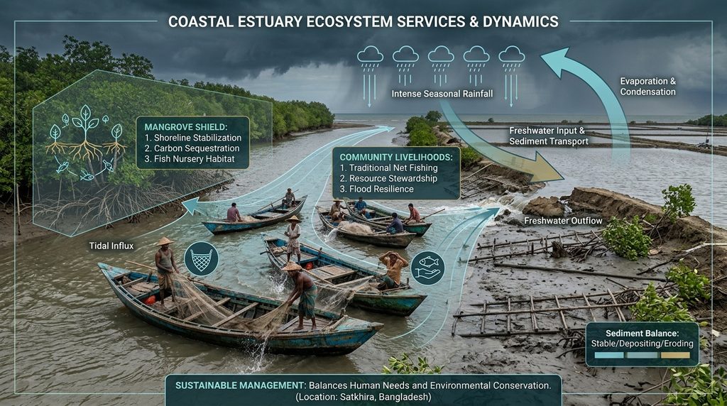
Why are climate change and coastal erosion major concerns?
Bangladesh’s coastal landscape is continuously shaped by interactions between river discharge, tidal processes, sediment transport, sea-level changes, and human activities.
Climate change is influencing several of these processes. Sea-level rise increases the potential for coastal inundation and saltwater intrusion, while stronger storm impacts can contribute to shoreline instability and damage coastal infrastructure. Changes in rainfall and river discharge may also affect sediment distribution, salinity patterns, and freshwater availability.
Coastal erosion represents another major concern. Along vulnerable sections of the coastline, the loss of land can directly affect settlements, agricultural areas, fishing infrastructure, and access routes to rivers and coastal waters. Erosion may also alter the physical characteristics of estuaries and nearshore habitats, potentially changing the distribution of aquatic organisms.
However, coastal erosion and accretion occur simultaneously in different locations. Some areas experience substantial shoreline retreat, while others gain land through sediment deposition. Therefore, understanding coastal change requires location-specific assessment rather than assuming that all coastal areas respond identically.
What is happening to coastal habitats in Bangladesh?
Bangladesh contains several important coastal and estuarine habitats that support fisheries production and aquatic biodiversity. These include mangrove forests, estuarine channels, tidal mudflats, salt marshes, seagrass-associated environments, and shallow coastal waters.
These habitats provide feeding, breeding, nursery, and sheltering grounds for numerous aquatic organisms. Juvenile fish, shrimp, crabs, molluscs, and other commercially important species depend on suitable environmental conditions during different stages of their life cycles.
Nevertheless, multiple environmental and human pressures are contributing to habitat modification and degradation.
Major concerns include:
- Mangrove degradation: Changes in forest cover and fragmentation can reduce habitat availability, nursery functions, and natural coastal protection.
- Estuarine habitat alteration: Changes in salinity, sediment transport, and freshwater discharge can influence habitat suitability and aquatic species distribution.
- Mudflat and wetland conversion: Land reclamation, infrastructure development, and other land-use changes can reduce feeding and nursery habitats.
- Coastal water quality deterioration: Pollution, sediment disturbances, and altered hydrological conditions may affect aquatic ecosystem health.
- Changing salinity regimes: Saltwater intrusion can modify freshwater and brackish-water habitats, influencing the distribution and productivity of fish species.
The combined effects of these changes may reduce habitat connectivity and affect the ecological processes that sustain coastal fisheries.
How do these changes affect fisheries and fishing-dependent livelihoods?
The degradation of coastal habitats and increasing climate variability can influence fisheries through both ecological and socioeconomic pathways. Changes in water temperature, salinity, dissolved oxygen, habitat availability, and hydrological connectivity may affect fish growth, reproduction, migration, and distribution.
For example, changes in estuarine salinity can influence the availability of suitable habitats for freshwater, brackish-water, and marine species. Similarly, the degradation of mangrove-associated nursery grounds may affect the survival and recruitment of juvenile fish and crustaceans.
These ecological changes can create several challenges for fisheries-dependent communities.
Major potential impacts include:
- Reduced fishing opportunities: Changes in fish distribution and habitat availability may increase travel distances and fishing costs.
- Declining catch stability: Environmental disturbances can contribute to seasonal fluctuations in fish availability and catch composition.
- Loss of fishing infrastructure: Shoreline erosion and storm surges can damage landing centres, fishing settlements, boats, storage facilities, and access roads.
- Income insecurity: Reduced fishing opportunities and unpredictable catches can affect household income, savings, and financial stability.
- Food and nutritional insecurity: Changes in access to locally available fish may affect household consumption and the availability of affordable animal protein.
- Increased occupational risks: Extreme weather, unstable shorelines, and unpredictable marine conditions can increase the physical risks faced by fishers.
Research involving mangrove-dependent fishing communities in Bangladesh has documented the combined livelihood challenges associated with cyclones, floods, salinity intrusion, and riverbank erosion. These findings demonstrate that environmental vulnerability is closely connected to household income, livelihood diversification, and adaptive capacity. ScienceDirect+2
Assessing coastal changes using GIS and remote sensing
An important approach to understanding the combined effects of climate change, coastal erosion, and habitat loss is the integration of Geographic Information Systems (GIS), satellite remote sensing, environmental monitoring, and socioeconomic assessment.
Satellite-based observations can provide valuable information about long-term shoreline dynamics, coastal land-use changes, vegetation distribution, and aquatic environmental conditions.
The proposed assessment can incorporate several important indicators:
1. Shoreline change assessment
Landsat and Sentinel-2 satellite imagery can be used to identify historical shoreline positions and evaluate coastal erosion and accretion patterns. Digital Shoreline Analysis System (DSAS) can help calculate shoreline change indicators, including:
- Shoreline Change Envelope (SCE).
- Net Shoreline Movement (NSM).
- End Point Rate (EPR).
- Linear Regression Rate (LRR).
These measurements can help identify erosion hotspots and locations experiencing significant coastal land transformation.
2. Coastal land-use and habitat mapping
Multispectral satellite imagery can support the classification of mangroves, wetlands, agricultural land, settlements, mudflats, and aquaculture areas. Comparing historical and recent land-cover maps can reveal habitat conversion, vegetation loss, and changes in coastal landscape connectivity.
3. Environmental suitability assessment
Sea surface temperature (SST), coastal water salinity, turbidity, suspended sediment concentration, and chlorophyll-a can be investigated to understand changes in coastal environmental conditions.
These indicators may help identify areas where changing environmental conditions could influence aquatic habitat suitability and fisheries productivity.
4. Fisheries and livelihood vulnerability assessment
Field surveys, household interviews, focus group discussions, and fisheries landing data can be integrated to examine the socioeconomic consequences of coastal environmental change.
Indicators such as fishing income, catch per unit effort (CPUE), fishing days, livelihood diversity, household assets, and access to alternative employment can provide insights into community vulnerability.
5. Integrated spatial risk assessment
Combining environmental and socioeconomic indicators within a GIS-based framework can help identify coastal communities experiencing overlapping exposure to shoreline erosion, habitat degradation, climate hazards, and livelihood insecurity.
A recent Bangladesh shoreline assessment using satellite remote sensing demonstrates the value of long-term spatial analysis for identifying erosion and accretion patterns along the coastal region. MDPI+1
Developing coastal adaptation and community resilience strategies
Addressing the combined impacts of climate change, coastal erosion, and habitat loss requires an integrated management approach that considers both ecosystem conservation and community welfare.
Based on the identified environmental and socioeconomic challenges, several practical adaptation strategies can be considered.
1. Ecosystem-based coastal protection
Restoration and conservation of mangrove forests, coastal wetlands, and other natural habitats can contribute to shoreline stabilization, biodiversity conservation, and the maintenance of important fisheries habitats.
2. Climate-resilient fisheries management
Developing adaptive fisheries management plans based on changing fish distribution, seasonal environmental conditions, and habitat availability can support sustainable fisheries production.
Improved fisheries monitoring and protection of important breeding and nursery grounds should be incorporated into coastal management programmes.
3. Coastal land-use planning
GIS-based coastal vulnerability maps can help identify erosion-prone areas, habitat degradation hotspots, and locations requiring land-use restrictions or protective infrastructure.
Coastal development should consider natural hydrological processes and the ecological importance of estuaries, wetlands, and mangrove ecosystems.
4. Livelihood diversification
Supporting alternative income-generating opportunities, including sustainable aquaculture, fish processing, value addition, and other locally appropriate activities, can reduce excessive dependence on climate-sensitive fishing activities.
5. Community-based early warning and preparedness
Improving access to weather forecasts, cyclone warnings, coastal hazard information, and emergency communication systems can help fishing communities prepare for environmental disturbances and reduce occupational risks.
6. Participatory coastal adaptation planning
Local fishers, community organizations, researchers, fisheries authorities, and coastal planners should participate in identifying environmental problems and developing adaptation priorities.
Research on transformational adaptation in mangrove-dependent fishing communities in Bangladesh highlights the importance of livelihood diversification, infrastructure, technological innovation, and community-level adaptation initiatives. ScienceDirect+1
Why does this research matter?
Bangladesh’s fisheries sector is closely connected to coastal ecosystem health, food security, employment, and the socioeconomic well-being of coastal populations. Environmental changes affecting coastal habitats can therefore create consequences extending beyond ecological degradation.
Understanding the combined effects of climate change, shoreline erosion, and habitat loss is particularly important because conventional approaches often address these environmental challenges separately. However, coastal ecosystems and human communities are interconnected, and their vulnerabilities cannot always be understood through isolated assessments.
An integrated research approach can help identify vulnerable coastal locations, understand the relationship between habitat degradation and fisheries productivity, and determine which communities require priority adaptation support.
The findings could contribute to:
- Evidence-based coastal adaptation planning.
- Identification of climate-vulnerable fishing communities.
- Conservation and restoration of critical fish habitats.
- Sustainable management of coastal and marine fisheries.
- Improved livelihood security and community resilience.
- Better integration of GIS and remote sensing into coastal resource management.
Bangladesh’s National Adaptation Plan (2023–2050) also recognizes climate-related risks to fisheries, including habitat degradation, salinity changes, declining fish diversity, and disruptions to fishing activities. UNFCCC+1
Looking ahead
Future research should focus on developing integrated coastal monitoring systems that combine satellite observations, field-based ecological surveys, fisheries statistics, and socioeconomic information.
Long-term shoreline monitoring can help identify areas experiencing continuous erosion and land-use transformation. Similarly, habitat mapping and environmental monitoring can provide information about changes in mangrove distribution, estuarine conditions, and potential fisheries habitats.
Further investigation is also necessary to understand how different coastal communities experience environmental changes and why some households are better equipped to recover from climate-related disturbances than others.
The integration of GIS, remote sensing, ecological assessment, and community-based research could provide a valuable scientific foundation for identifying priority intervention areas and designing locally appropriate adaptation strategies.
Ultimately, coastal resilience planning should move beyond protecting physical infrastructure alone and recognize the importance of maintaining healthy aquatic ecosystems, sustainable fisheries, and secure livelihoods.
Conclusion
Climate change, coastal erosion, and habitat loss represent interconnected environmental and socioeconomic challenges for Bangladesh. Their combined effects can influence coastal ecosystem functioning, fisheries productivity, and the livelihood security of fishing-dependent communities.
Addressing these challenges requires an integrated approach that connects scientific monitoring, habitat conservation, sustainable fisheries management, coastal land-use planning, and community participation.
Protecting coastal ecosystems is not simply an environmental priority; it is also essential for safeguarding fisheries resources, supporting food security, and maintaining the livelihoods of coastal populations.
The objective is not only to understand how Bangladesh’s coastline is changing, but also to determine how science-based adaptation, ecosystem conservation, and community participation can help build a more resilient coastal future.
Research perspective: This article presents a research-oriented assessment framework. The proposed GIS, remote sensing, ecological, and socioeconomic analyses require further location-specific investigation. Potential fisheries and livelihood impacts should be validated through field observations and empirical data rather than assumed from shoreline changes alone.
Selected scientific and institutional sources
- Islam et al. (2021). Transformational adaptations to climatic hazards: Insights from mangroves-based coastal fisheries dependent communities of Bangladesh. Marine Policy. Read research article.
- Munir (2025). Climate change impacts & small-scale fisheries: A case study of adaptation and resilience in Bangladesh. Read case study.
- Bangladesh National Adaptation Plan (2023–2050). Read national plan.
- Shoreline Change Assessment in the Coastal Region of Bangladesh Delta Using Tasseled Cap Transformation from Satellite Remote Sensing Dataset. Read research article.
- Dasgupta et al. (2016). Impact of climate change and aquatic salinization on fish habitats and poor communities in southwest coastal Bangladesh and Bangladesh Sundarbans. Read World Bank research.